- Men
- Women
- Footwear
- Paddling
- Hiking
- Camping
- Travel
- Log in
- Men ▾
- Women ▾
- Footwear ▾
- Paddling ▾
- Hiking ▾
-
Camping
▾
- Tents
- Solo
- 2 Person
- 3 Person
- 4 Person
- Family
- Dining Tents & Tarps
- Hammock Tents
- Footprints, Poles & Pegs
- Scratch & Dent Items
- Sleeping Bags
- Sleeping Bags
- Stuff Sacks
- Blankets & Liners
- Sleeping Pads
- Sleeping Pads
- Pillows & Accessories
- Furniture & Hammocks
- Chairs & Tables
- Hammocks
- Cots
- Water Treatment
- Kitchen
- Water Bottles
- Stoves & Fuel
- Cookware
- Utensils & Dishes
- Camp Food
- Campfire Accessories
- Headlamps & Lights
- Solar Power & Batteries
- Knives, Saws & Tools
- First Aid & Survival
- Insect Protection
- Personal Hygiene & Sunscreen
- Cord, Straps & Buckles
- Maps & Books
- Games & Gifts
- Travel ▾
- Cart Cart
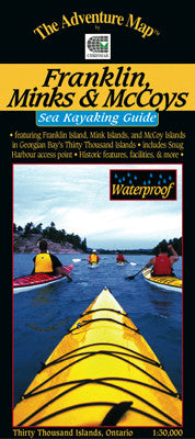
Chrismar Franklin Mink McCoy Islands Map
$13.95 CAD
![]()
This is probably the most popular sea kayaking area in all of the Great Lakes.
The east shore of Georgian Bay to the west of Parry Sound and Killbear Provincial Park is dotted with thousands of islands. This map, the first of a series along the coast, includes Franklin Island near the coast, the Mink Islands beyond them and the McCoy Islands to the north.
Aside from the extraordinarily beautiful rocky islands, the area has a rich boating, fishing and lighthouse keeping history, with its fair share of shipwrecks and seafaring stories. Much of this fascinating human history is detailed in text which covers the entire backside of this 46x61cm (18x24 inch) waterproof map (folded 4x9 inches).
You'll also find information and great colour photographs about the geologic and natural history of the area, plus significant sections about planning your trip, route suggestions, gear guide, backcountry etiquette, safety concerns, contact information and much more.
This 1:30,000 scale map has extraordinary geographic detail plus special features showing shallow waters, shoals, buoys, ranges, lighthouses and other nautical items. It combines the most useful features of topographic maps and nautical charts, which is just what sea kayakers prefer and have been asking us for. There is even a compass rose.
On waterproof plastic as usual, so sea kayakers can get it as wet as they like without it disintegrating! Can even double as a useful rain hat.
Like all Adventure Maps® this one is completely original and made specifically for the sea kayaking audience.
You may also like
General Info
Hours
M-W: 10am - 5pm
Th-F: 10am - 7pm
Sat: 10am - 5pm
Sun: Closed
*Closed on all Statutory Holidays and the Civic Holiday.
Store Details
Phone (905) 688-0160
Address:
420 Vansickle Rd. St. Catharines, ON, L2S 0C7
News & Updates
Sign up to get the latest on sales, new releases and more…
© 2025 Outdoors Oriented.