- Men
- Women
- Footwear
- Paddling
- Hiking
- Camping
- Travel
- Log in
- Men ▾
- Women ▾
- Footwear ▾
- Paddling ▾
- Hiking ▾
-
Camping
▾
- Tents
- Solo
- 2 Person
- 3 Person
- 4 Person
- Family
- Dining Tents & Tarps
- Hammock Tents
- Footprints, Poles & Pegs
- Scratch & Dent Items
- Sleeping Bags
- Sleeping Bags
- Stuff Sacks
- Blankets & Liners
- Sleeping Pads
- Sleeping Pads
- Pillows & Accessories
- Furniture & Hammocks
- Chairs & Tables
- Hammocks
- Cots
- Water Treatment
- Kitchen
- Water Bottles
- Stoves & Fuel
- Cookware
- Utensils & Dishes
- Camp Food
- Campfire Accessories
- Headlamps & Lights
- Solar Power & Batteries
- Knives, Saws & Tools
- First Aid & Survival
- Insect Protection
- Personal Hygiene & Sunscreen
- Cord, Straps & Buckles
- Maps & Books
- Games & Gifts
- Travel ▾
- Cart Cart
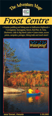
Chrismar Frost Centre Area Map
$13.95 CAD
![]()
This popular map showcases over 500 km2 of wilderness in the Haliburton Highlands/Muskoka Lakes region of Ontario, including the popular 200 km2 tract of crown land known as the Leslie Frost Centre lands.
A great destination for paddlers and backpackers alike, this map covers stretches from Livingstone and Fletcher lakes in the north, to Halls Lake in the south and from Lake of Bays to the west to Kennisis and Kimball lakes in the east.
This completely original map features extraordinary topographic and water details, as well as hiking trails, campsites, portages, access points, facilities and other attractions. The back side is covered with colour photos and lots of information about natural history, suggested routes, safety tips, contact information and much more.
Following Chrismar's popularization of this area over 10 years ago with their first Frost Centre & Area Adventure Map®, the local municipality has now implemented a revenue-capturing user-pay system for overnight visits (day-use is free).
You may also like
General Info
Hours
M-W: 10am - 5pm
Th-F: 10am - 7pm
Sat: 10am - 5pm
Sun: Closed
*Closed on all Statutory Holidays and the Civic Holiday.
Store Details
Phone (905) 688-0160
Address:
420 Vansickle Rd. St. Catharines, ON, L2S 0C7
News & Updates
Sign up to get the latest on sales, new releases and more…
© 2025 Outdoors Oriented.