- Men
- Women
- Footwear
- Paddling
- Hiking
- Camping
- Travel
- Log in
- Men ▾
- Women ▾
- Footwear ▾
- Paddling ▾
- Hiking ▾
-
Camping
▾
- Tents
- Solo
- 2 Person
- 3 Person
- 4 Person
- Family
- Dining Tents & Tarps
- Hammock Tents
- Footprints, Poles & Pegs
- Scratch & Dent Items
- Sleeping Bags
- Sleeping Bags
- Stuff Sacks
- Blankets & Liners
- Sleeping Pads
- Sleeping Pads
- Pillows & Accessories
- Furniture & Hammocks
- Chairs & Tables
- Hammocks
- Cots
- Water Treatment
- Kitchen
- Water Bottles
- Stoves & Fuel
- Cookware
- Utensils & Dishes
- Camp Food
- Campfire Accessories
- Headlamps & Lights
- Solar Power & Batteries
- Knives, Saws & Tools
- First Aid & Survival
- Insect Protection
- Personal Hygiene & Sunscreen
- Cord, Straps & Buckles
- Maps & Books
- Games & Gifts
- Travel ▾
- Cart Cart
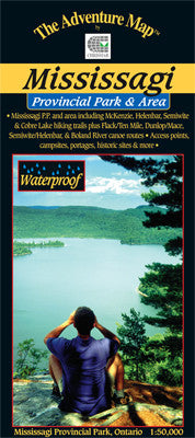


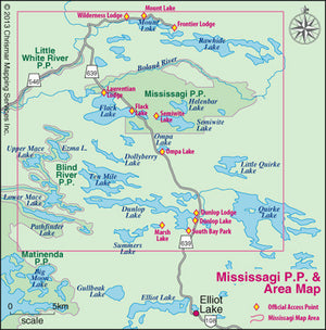
Chrismar Mississagi Provincial Park & Area Map
$14.95 CAD
– Sold Out![]()
This guide to this superb hiking and paddling area just north of Elliot Lake, Ontario, includes not only Mississagi P.P., but also the Rawhide Lake Conservation Area, and portions of Matinenda and Blind River P.P.s. That whole area is available for paddling and hiking opportunities with over 50 kilometres of rugged hiking trails with really top-notch lookouts (see the map cover), and over 150 kilometres of excellent wilderness paddling routes.
This waterproof, 1:50,000 scale, completely original (like all the others) topographic map has unprecedented detail, and includes all hiking trails, portages, access points and backcountry campsites, plus many other features.
The map measures 21x24", has a contour interval of 15 metres, and includes text and photos about natural and human history, trail and canoe route descriptions, safety tips, contact info, great colour photographs - in short just about everything you'd want to help you plan and enjoy your trip.
You may also like
General Info
Hours
M-W: 10am - 5pm
Th-F: 10am - 7pm
Sat: 10am - 5pm
Sun: Closed
*Closed on all Statutory Holidays and the Civic Holiday.
Store Details
Phone (905) 688-0160
Address:
420 Vansickle Rd. St. Catharines, ON, L2S 0C7
News & Updates
Sign up to get the latest on sales, new releases and more…
© 2025 Outdoors Oriented.